
Home |
WATEX™ Solutions | WATEX™ Fire Prevention & Ecoforestry Mapping |
THE WATEX™ SYSTEM, A KEY TECHNOLOGY FOR FIRE PREVENTION IN CHILE
Back
WATEX™ Fire Prevention & Ecoforestry Mapping
THE WATEX™ SYSTEM, A KEY TECHNOLOGY FOR FIRE PREVENTION IN CHILE
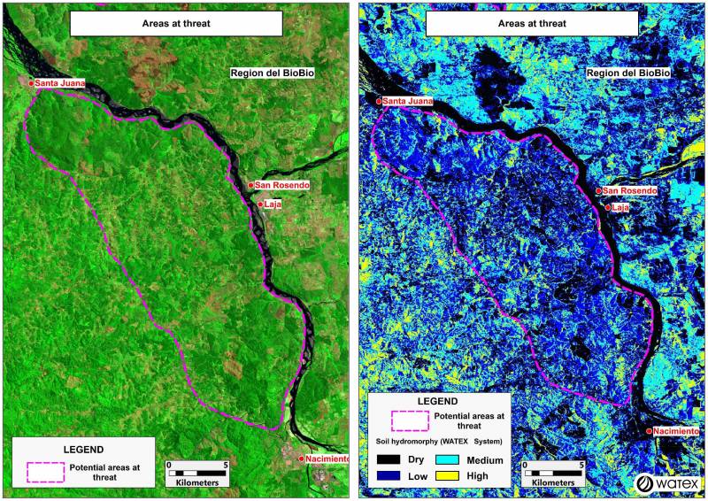
The WATEX™ Process mapping results indicate areas exposed to forest fires.
In the Bio Bio region of Chile, near San Rosendo, the Landsat map of 2016 (left) (one year before the fires) does not show any strong anomaly.
Despite the 825 mm of annual rainfall, the WATEX™ map of 2011 (right) already indicates hydromorphy anomalies in the dark area outlined by the dotted pink polygon.
UPDATE 2023: As of February 9th, 2023, a total of 508,125 ha has burned in Chile in destructive wildfires that occurred in February 2023. Unfortunately, the specific area displayed in this article has burned and show that the WATEX™ Fire Prevention Mapping solution could have prevented this disaster.
Contact us to learn more about our WATEX™ solutions and how to improve environmental protection in your area!
Contact Us
