
Home |
WATEX™ Solutions | WATEX™ Groundwater Mapping |
GROUNDWATER EXPLORATION FOR AN INTERNATIONAL INSTITUTION IN ETHIOPIA (2013)
Back
WATEX™ Groundwater Mapping
GROUNDWATER EXPLORATION FOR AN INTERNATIONAL INSTITUTION IN ETHIOPIA (2013)
CONTEXT
Recurrent droughts in arid regions:
In the context of emergencies, field insecurities and urgencies, conventional methods of mapping groundwater in the greater Horn of Africa region have largely been limited in addressing recent famine and drought, therefore yielding results too fragmented and impracticable for achieving meaningful sustainable responses.
In this context, the International Rescue Committee (IRC) requested the WATEX™ System approach developed by RTI to obtain comprehensive, rapid, large-scale hydrogeological investigations improving the effectiveness of drought mitigation efforts in the region.
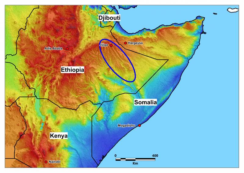
This groundwater exploration survey covered over 6 months a surface of 56,000 km² in the Somali region of eastern Ethiopia, all along the Somaliland border.
The WATEX™ System revealed the presence of a giant aquifer that had not been documented in prior literature or scientific research. It is called the East Kamara aquifer or EKA.

HYDROGEOLOGICAL ASSESSMENT
The East Karamara aquifer located on the eastern flanks of the Karamara Mountain Range, situated 3 km southeast of Jijiga town. It is buried between 50 to 700 m below the surface along the Jerer Valley, it is 1 to 35 km wide and 200 km long.
The structure is composed of highly permeable karstified limestones and sandstones. It is partially confined by impermeable aquicludes of the Karamara basaltic range to the west, the uplifted basement to the east and sealed by shale formations above.
Groundwater flows through the aquifer in an indicative 143° SE direction, with a high probability of artesian conditions in the southern half of the aquifer.
The estimate of the storage capacity of this aquifer is under evaluation by the USGS but its geometry extending to 200 km long with an average of 15 km width might reveal the major aquifer of this eastern part of Ogaden.

MODEL VALIDATED BY INTERNATIONAL INSTITUTION (IRC)
These outcomes, generated through the WATEX™ system, hold great promise for enhancing the well-being of the nearly one million inhabitants residing in this water-scarce region, many of whom live in impoverished conditions with restricted access to basic amenities and clean water.
The accuracy of the model has been demonstrated by the drilling of 30 successful wells by IRC from 150m to 700m deep, which were guided by the WATEX™ map.
Contact us today to learn how our WATEX™ Groundwater Mapping projects can assist your company!
Contact Us
