
Home |
WATEX™ Solutions | WATEX™ Groundwater Mapping |
THE WATEX™ GROUNDWATER MAPPING SOLUTION ENABLING THE DISCOVERY OF GIANT GROUNDWATER RESERVES IN KENYA (2013)
Back
WATEX™ Groundwater Mapping
THE WATEX™ GROUNDWATER MAPPING SOLUTION ENABLING THE DISCOVERY OF GIANT GROUNDWATER RESERVES IN KENYA (2013)
The WATEX™ Groundwater Mapping solution is a revolutionary technology to discover colossal groundwater reserves.
CONTEXTTurkana is one of the hottest, driest and poorest parts of Kenya and has been hit by devastating droughts since 2011. Many of the region's inhabitants are nomadic herders with their livestock. They are especially vulnerable to the lack of rain. The area is sparsely populated and prone to conflict over current scarce resources.
Of Kenya’s 53 million people, 15 million lack access to safe water and 22 million lack access to basic sanitation (water.org, 2022).
A survey of groundwater resources of a 36,000 km² zone in Turkana County, Kenya, was carried by RTI on behalf of UNESCO for the Government of Kenya from July 2012 to February 2013. The investigation was conducted using the WATEX™ System, as well as ancillary field data and satellite imagery.

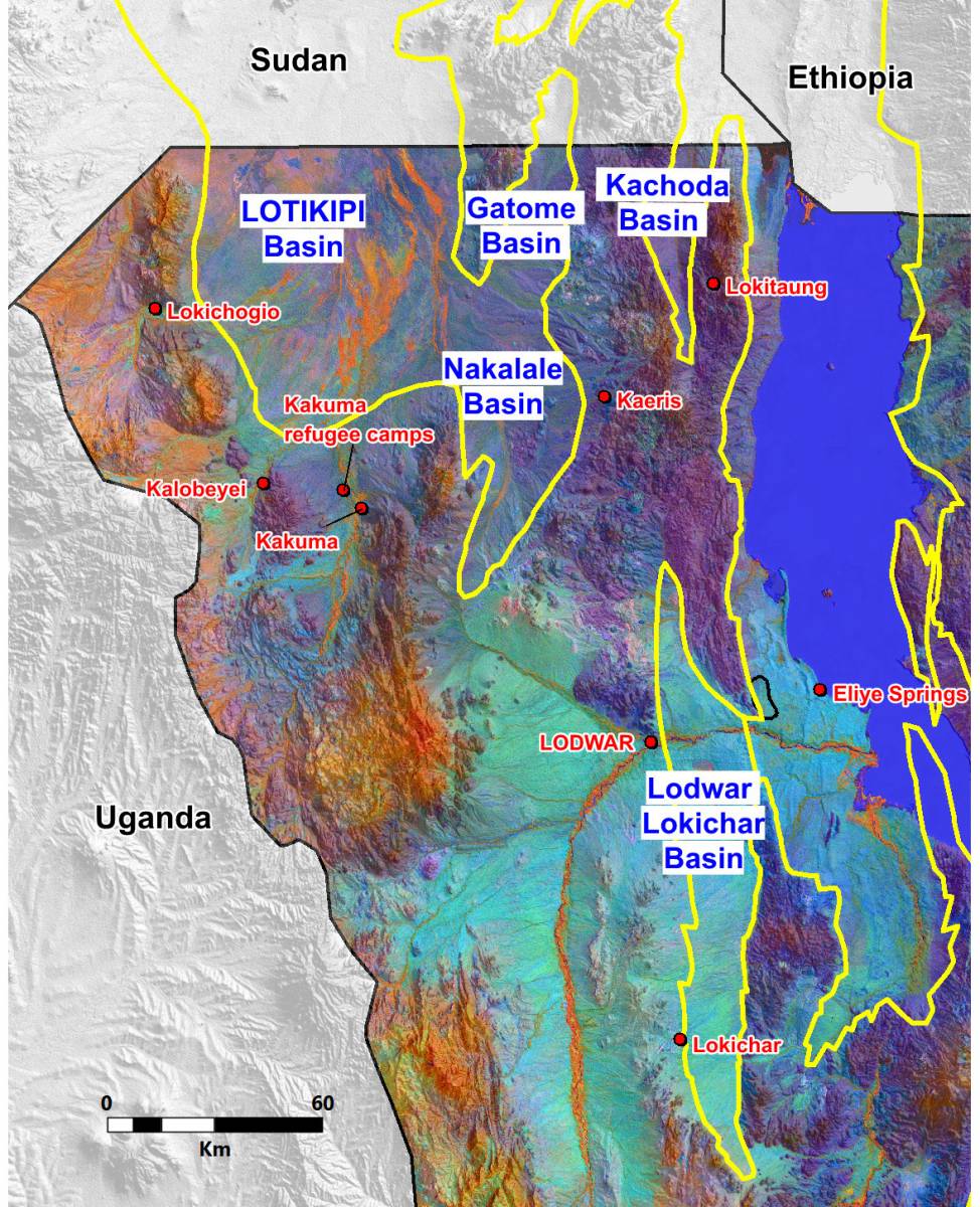
DISCOVERY OF 4 GIANT AQUIFER DISCOVERY IN TURKANA, NORTHERN KENYA
This WATEX™ survey revealed in 2013, the presence of 4 giant aquifers never recorded before in Northern Kenya. They are all located on the Western part of Turkana Lake.
These aquifers are related to the East African rift, where open fractures can allow hydrothermal saline water to enter, potentially competing with freshwater from rainfall.
With the WATEX™ system, RTI Exploration has developed a successful strategy to avoid the pitfall of saline water in each of these aquifers after 10 years of experimentation on several well. A good management of these aquifers can make Turkana County the breadbasket of East Africa in the years to come.
- The Lotikipi Aquifer is the biggest one and covers one million hectares. It is replenished by seasonal rivers flowing from the highlands of Uganda, South Kenya and South Ethiopia. Moreover, these rivers contribute to enrich the soils with massive deltaic sediments. This aquifer is a subsiding basin which, according to seismic data, is 4 km deep and the borehole Lotikipi-1 drilled in July 2013, under the recommendations of RTI, has revealed 3 different aquifers from 120 m to 330 m.
- The Gatome-Nakalale aquifer covers a surface of 290 000 ha. It is a mult-layered aquifer trapped in a hemigraben structure linked to the rifting of Turkana Lake. It has never been drilled since the discovery.
- The Kachoda aquifer covers a surface of 66 000 ha. It is a hemigraben structure aquifer with an approximate depth of 400 m which has never been drilled.
- The Lodwar Lokichar aquifer is also an important hemi-graben strectching from north to South on 150 km, only 5 km east of Lodwar. This aquifer is a paleo-delta covering 250 000 ha with a depth of 700 m over a width of 20 km with excellent quality of porosity and permeability. It has been intensively drilled in the close vicinity of Lodwar, capital of Turkana, since the WATEX™ discovery in 2013 and contributed to the intense demographic growth of Lodwar from 12 000 persons in 2013 to 120 000 persons in 2022. This aquifer is known in Lodwar area as the Napuu aquifer. It has not been drilled yet outside a radius of 10 km from Lodwar and a huge asset remains to be explored.
These aquifers are related to the East African rift, where open fractures can allow hydrothermal saline water to enter, potentially competing with freshwater from rainfall.
With the WATEX™ system, RTI Exploration has developed a successful strategy to avoid the pitfall of saline water in each of these aquifers after 10 years of experimentation on several well. A good management of these aquifers can make Turkana County the breadbasket of East Africa in the years to come.

PRESS COVERAGE
Some articles covering these groundbreaking discoveries are available below:
Contact us for more information on the WATEX™ solutions!
- Massive underground water reserve discovered in drought-stricken Kenya: The Verge (September 11, 2013)
- Huge aquifers are discovered in North Kenya: The New York Times (September 11 and 20, 2013)
- Water Mapping Technology Rebuilds Lives in Arid Regions: NASA Landsat Science (January 26, 2015)
Contact us for more information on the WATEX™ solutions!
Contact Us
